Things are working out pretty good currently.
On July 11th, after sitting in the Stevens pass ski lodge for 6 hours or more and having some bad food, we went out to good ol' highway 2 and stuck our thumbs out. We were kind of having a crappy day but then when we started trying to hitchhike we were laughing and having fun. I guessed it would take us ten minutes and it took us exactly ten minutes.
Two old hippies pulled onto the shoulder and gave us a ride. They were driving to Seattle to pick up marijuana. Recreational pot is legal in Washington now, wow! Then they offered us a hit of their pipe. They had no teeth so we were wary but, oh well, we hit it anyway.
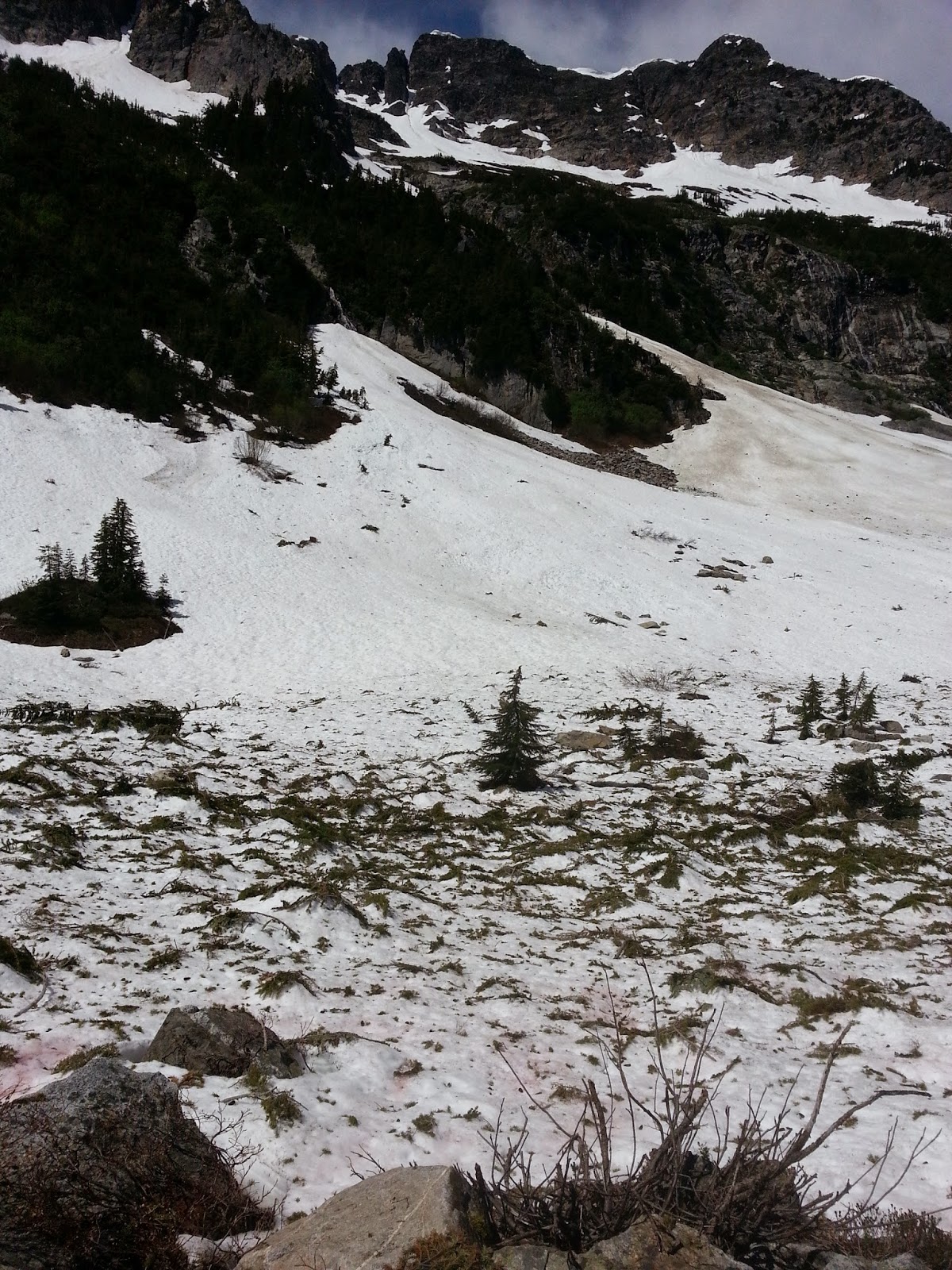
We were dropped off 12 miles down the road at a parking lot for Deception Falls, where there supposedly is a trail that connects to the Pacific Crest Trail halfway through section J. This is the snowbound section we tried to hike into 2 days before. Deception eh, whats so decieving!? We walked up to the falls, it was a big cascade, there was a tunnel under the highway we walked through. Then a dead end. We climbed up to the side of the highway and there saw a faint trail. We followed it.
It was rough and unsigned and brought us to more waterfalls. We found ourselves stoned as we wandered into this dripping rainforest. Moss clung to the trees and carpeted the ground. Tall grand ceders and drooping hemlock trees surrounded us, with an undergrowth of ferns. We came eventually to a sign with a map and we hiked 3 miles in.
We camped that night in a glorious spot, wood didn't burn well there, it was very moist. In the morning we hiked about 12 miles. We forded some big streams and saw some waterfalls. We found a warm shallow alpine lake and bathed in it. Then we found that Pacific Crest Trail. We were kind of killing time because we had still 4 days worth of food intended for section J. We didn't need to be another week early, this snow needs to melt! So we were still hiking around section J just more dysfunctionally. It was good training. We found the most beautiful spot that night.
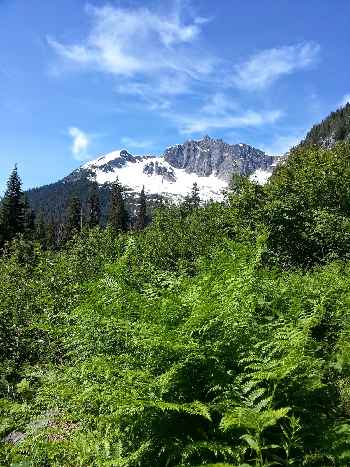
The next day we climbed to the top of Piper Pass. It was the snowbound pass that had defeated us on July 10th. We went around the backside and conquered it. There was no snow on this side, Deception Creek bypassed all the miserable white stuff. The view was great up there, we got our first look at wicked Glacier Peak, the mountain responsible for all this wild terrain, what a beast.
So without enough food to continue to Snoqualmie we left the way we came. We spent that night down on Deception Creek and both cleaned ourselves very well on a swim in the rushing stream. The next day we vamoosed.
We hit the highway. We intended to hike to Skykomish and find some way to get to 100 mile distant Snoqualmie. There wasn't a trail to get to Skykomish like I had thought and searching for it brought us on a mile or two road walk along the shoulder of highway 2, affectionately known as the "highway of death". Then we hiked a pretty backroad back and wound up wandering around a dirt road picking berries. We gorged ourselves on salmonberries, thimbleberries, purple thimbleberries, and the most delicious blackberries ive ever had.
So Maggie said, through a mouthful of berries, "I wish someone would just offer us a ride so we didn't have to hitchhike." 10 minutes later a lady pulls up in a Prius and offers us a ride! She was old, quirky, and nice. She brought us right to the magnificent Skykomish deli and who did we see walking past but our friend Heidi. A girl we met on the trail 2 days earlier who is hiking northbound through Washington. We congratulated her on making it to Skykomish. She gave us a peach and a bunch of cherries and then her ride showed up and off she went to Seattle. It was perfect timing that we saw her again.
Then a stranger handed us a huge chocolate muffin. Then we got ice cream and sandwiches and someone else offered us a ride the next 10 miles and brought us right back to Andrea Dinsmores doorstep. Back to the wonderful hiker haven for showers and a PCT movie night!
In the morning we had the grand breakfast at the Baring store and the great man Jim drove us all the way around the mountains, a two hour drive to Snoqualmie pass. He talked my ear off the whole time it was fun. We found ourselves in a foreign town again, back on our own, and wandered into the most dirty, disorganized Chevron station ive ever seen. Thete were boxes on the floor, food everywhere, shoe boxes stacked to the ceiling. I found the bad tempered mexican man running the place and asked him about my PCT general delivery coming here. "Its in the back" he tells me. So I wander off and find my way into turned off walk in cooler filled to the cieling with junk. Flipped over and beaten up among the horde was my food box with the turquoise tape. I grabbed it. I saw the back kitchen of this place and there was a tv on the ground, bags of meatballs on the ground, dirty pans and boxes laying everywhere, and barely enough floor space to walk around, yikes!
So we met the trail angel Dan and he let us hang out by his food cart "the Aardvark" for hours. We found a bag of cookies, Dan gave us beef stew. He gave us each two 16oz beers for free. He gave us a bowl of chicken curry. A stranger walked up and handed us a huge blueberry muffin!
Then who was to show up but our friend Jes. He hiked section J and had just made it through. Great seeing him again and we traded socks for chocolate. We eventually shoved off, hiking two miles in past I-90 to a lake and camped. Wow what a week, cannot believe the kindness of strangers. We are having an excellent journey. Then it was today. We got on the PCT for real here in segment I. Snoqualmie pass to White pass. 99 miles and several mountain passes. I believe the snow is melted here, its July 16th.
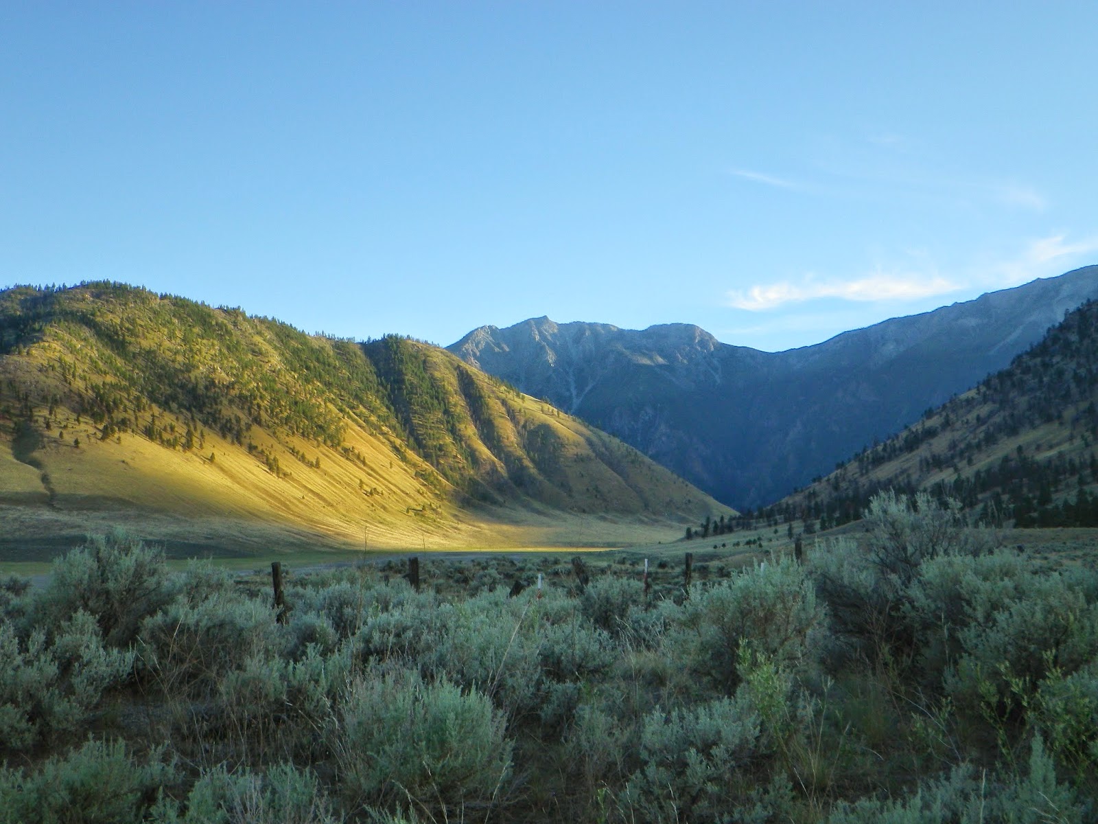
Today we hiked 21 miles and learned that wow, no snow means- no water! We've been used to constant water. Today we went 14 miles and then instead of stopping to camp went forward. I thought there was plentiful water but have been misreading the maps a tad. There was suddenly no water for 7 miles and we needed to be by it to camp, we didn't have enough water to cook. We made it to a spring, found a nice spot nestled in the beargrass, and now are looking forward to this grand adventure. Finally saw mt Rainier today, he's immense, looks like a ghost mountain.
Monday, July 28, 2014
Tuesday, July 22, 2014
Purgatory
Well it s been a tough week but also exciting. Definitely challenging.
On July 5th we hiked back to Stehekin with our friend H.R. We went fast, did 10 miles in 2.5 hours and made the 3 p.m. shuttle bus to Stehekin, which takes us 11 miles into town on a dirt road. We hiked 18 miles that day and spent the night in a luxurious spot on the lake shore, it's the most magical place ever.
The next day we caught this ferry, it was $35 per person and they only accept cash or check and there was no ATM in town. Good thing I have checks! It was a long ride down this narrow 50 mile lake, the North Cascades are beautiful. We came to the city of Chelan and tried to find a free spot to camp on the outskirts of town but that didn't work the town was too big. It sucked and we had a rough time. Finally we gave in and bought a $35.00 campsite which was right next to the loud highway and busy sidewalks and the campground was bursting with people.
The next morning we ran to catch the bus and found ourselves flying across the dusty desert lands of Eastern Washington. We were dropped at a pleasant bus station in Wenatchee where that we purchased a couple bus tickets to Skykomish. We were whisked back up into the mountains.
The bus, Seattle bound, made a special stop on the side of the highway for us, the ticket lady said she had never sold a bus ticket to Skykomish before. It drove away, leaving us in the dust. We both were a little startled by being dropped off like that in this foreign land and I immediately began searching for a place to hide. I climbed down the side of the highway and walked around some pretty riverbanks until I found a little rivulet that ran into a marshy area. I found this nice sandbar and took Maggie's bag there and instructed her to climb down the river banks and through the river to her great detest. The highway roared buy us and echoed around like thunder with each passing car. I liked the swamp but she didn't and we didn't get along very well that night.
We wandered the ghost town of Skykomish. It was a simple empty town on the Great Northern Railroad. Stark and spacious and beautiful, with a large abandoned historic hotel in the town center and not much else. The trains constantly past. I had absent mindedly left my sleeping pad in Stehekin and had been sleeping on the cold ground since. I ordered a new one next day shipping to this wonderful persons house named Andrea Dinsmore. In the morning she came and picked us up from the post office and brought us 10 more miles down the road to her house in the tiny town of Baring. A friend we had never met came to pick us up.
Her and her husband Jerry are PCT "mom and dad", they run an informal hostel based on donations for PCT hikers. "The Dinsmores Hiker Haven". We stayed in a room there with bunk beds showers, laundry, even spare clothes you could wear while you wash yours. So much reading material about the PCT, the walls plastered with PCT history. Maggie wore a dress that belong to her hero Anish. A girl from Michigan who holds the PCT speed record and has an inspiring story. We talked about this girl all the time and now Maggie's wearing her dress that was cool. We cut 60 feet of Tyvek into 3 foot by 6 foot sections for ground cloths for the hikers camping on snow.
Also there was a bunch of free stuff. I grabbed some expensive anti fungal foot cream, we upgraded our bug hats, there was all the free backpacking toilet paper one could want and chocolate peanut butter to eat! Then she gave us a jar of "Biscoff", cookies in peanut butter form, but it wasn't peanut butter it was straight cookies. Cookie butter. It was heaven.
In the morning we had breakfast with the 14 or so residents of Baring at the general store where they gather for breakfast daily. When the train goes by all the people of the town wave at it as big as they can. I could just picture the people on the Amtrak seeing this magical mountain town out the window as they passed, with everybody waving including us. A nice guy gave us a ride 20 miles east to the top of Stevens Pass, to the PCT.
We hiked up further and quickly found the fast melting snow fields. One by one we crossed them. As we passed farther into the Alpine Lakes Wilderness we found a trail contouring the steep mountain side. The snow was clinging to the steep slope, creating constant obstacles to cross above dizzying views. You have to kick steps into the snow to cross it, but sometimes it conceals streams and you might see a hole in the snow, its just a thin snow bridge there, and those snowfield you have to climb down the mountain side or up it to move around them. It was uncomfortable and dangerous on the slippery mud, it sucked. There was one sketchy part.
Then the trail was completely snow covered. We got turned around and found ourselves heading steeply down the Icicle Creek Trail. We arrived at beautiful Josephine Lake and continued further down. Down and down to an abyss.
At the bottom we hit a pine forest completely blanketed in a large snow drift. A dead end. I tried to scout my way across it. I didn't realize it but this was the miserable Icicle Creek drainage. I crossed a snow bridge over a flowing stream. I left Maggie behind and scouted ahead. There was water flowing beneath me under the snow, I crossed more snow bridges. Then suddenly I fell through. My pack caught me and my feet were dangling free. Adrenaline surged! I escaped it and ran panicked ahead. I was trapped on the wrong side of a weak bridge. Thin ice. I was able to navigate my way back to Maggie through the bushes. I still haven't told her this happened! This is the wrong way is all I said.
It was July 9th, the anniversary of our friends death last year and a hummingbird followed us all day. We camped by Lake Josephine and found the PCT again in the morning. It was very discouraging. The trail was entirely snowbound for miles. We don't like it and aren't having it. A little snow is ok, "light mountaineering" but these conditions we aren't prepared for. So we turned back the miserable trail we came on and found ourselves sitting confused on a ski lift at the top of Stevens Pass.
There's too much snow here what can we do? Wait for it to melt? Skip Washington and try Oregon? Bus to California, flip flop and hike north? We were trapped, on one side a scary highway we need to travel far on with no car and on the other side a huge wall of impassible mountains. We were at the ski lifts of purgatory and the mosquitoes were eating us alive. We camped halfway down the slopes in a fog of mosquitoes the likes of which I've never seen. We were frustrated and miserable. In the morning we woke up still pretty miserable but not so bad, and sat in a ski lodge for hours and hours, the day passed us by and we tried to make a plan...
Monday, July 7, 2014
Pacific Crest Trail- what trail? Detouring Glacier Peak wilderness
Well today was a fiasco.
We hiked 10 miles south from Stehekin yesterday after relaxing there, to camp by a beautiful raging stream. I had find fire going instantly, the North Cascades are hospitable for life in many ways; fire starts easy yet water is plentiful. They have LOTS of mosquitos though.
Today we hiked for over for over 8 hours yet were only able to cover five miles, but we hiked many more than that. Yesterday we averaged 4 miles per hour at one point and today it was 5 miles in 8 hours. After cedar camp, where I grabbed a beautiful cedar walking stick, the trail climbed up to crest Suiattle pass. It was the north face, we were prepared for snow. This area is famous for its snow, Mt Baker holds the world record for snowfall accumulation, but from my research the PCT is supposed to be passible by late June and snow free by mid July. Today was the fourth.
So we climbed happily up. We faced one obstacle after the next as usual. Huge, smooth 50 foot tall Douglas fir trees lay fallen across the switch backing trail. Creeks roared down the hill side which we crossed with ease. We bathed under a waterfall. We came to a destroyed bridge and crossed the river over a log. All of a sudden we hit the snow field and the difficult obstacles.
An avalanche had completely demolished the trail, and wreaked havoc on the land. Dozens, if not hundreds, even thousands, of trees were collapsed across our path! One by one we crossed them, over some and under some with our fully loaded packs. We lost the trail for a bit while we crossed snow that was textured completely with pine boughs. Then we found a small piece of uncovered trail and a bridge that was torn to bits and half under snow, but we're still able to cross the stream over it.
After that the trail was gone. To our left we saw complete chaos, a jumble of trees and branches, completely unpassable. To our right we saw what looked like where the trail hopefully ran, through some stands of less destroyed but sickly looking pines. Behind that was the slope of the huge snow field that curved up the mountain to end abruptly at rock cliffs where 6 waterfalls cascade down, one huge one, some free falling off overhangs, one hitting a smooth boulder and breaking into dozens of little waterfalls, all pouring down to be covered by the melting snow field. They began high above where other snowfields cling to the cracks of the top rocks of the mountains, which terminates far above us in jagged, black grey points.
I had been to places like this before in Glacier, Colorado, and Wyoming and thought I was ready for the challenge. We took off through the stand of trees and soon we were surely off the trail. I believed we were above it and so we tried to head downwards across the snow and through the bushes. We crossed numerous streams and encounters snow bridges over the streams. At some point I climbed on a rock to look around and try to find some semblance of a trail. There was nothing, just snow and bushes and streams and rocks and destroyed pine trees everywhere, sweeping views in all directions, but in the foreground utter chaos. We were bushwhacking now, and then Maggie fell through an ice bridge to her waist and got wet and cried. It was scary.
I thought we were paralleling the trail only it was below us so I left my bag and scouted down the cascading streams in vain attempts to find it. Upon my failure we doubled back to the busted foot bridge. Then we set off down hill through the Avalanche to a large area of tall standing spruces and didn't find the trail there either. After doubling back to the bridge once more we went above it all and found an uncovered bit of trail high up on the snow field. It was dry and we warmed are numb feet on it. Then we pressed onward.
We crossed huge snow fields and tried with all our might to stay with the trail. We crossed thick snow bridges with water we could hear flowing beneath us. But we tried not to do that. I stuck my stick into the snow and it finally snapped in half. I had a huge bleeding gash on my arm and Maggie's legs were bloody. Then the hill became steep and we still couldn't see the pass but we tried with all our efforts to claw our way up this thing. I fell through the snow three times up past my waist trying to climb around a buried tree. The trail switchbacks steeply but was buried so you had to just climb straight up and it was grueling. Maggie cried some more as the snow began to soften in the afternoon and we kept falling through. We were prepared to climb straight up buried switch backs but it was the constant obstacles of scratchy pine trees that made this so challenging.
So I finally said "Alright if we are gonna skip the North Cascades then we need to at least get to the top of this thing, we are so close now." But we weren't close. There were four mountain passes that were at least this big that contoured Glacier Peak, a supervolcano, in the 8 days between here and Skykomish. That was starting to look like a foolish endeavor. It's been an especially heavy snow year in the North Cascades which really sucks.
At some point where I was almost at the verge of tears myself I realized we were nowhere near the top. A raging creek flowed under a thin layer of snow to my left down the slopes of this wicked mountain. Another creek flowed under the snow to my right. Above me now was a gnarled tangle of branches and pine limbs, pure suffering especially with my pack of 7 days of food. Let's get down.
We went down and decided we must skip this segment. Of course this is the most direct way to the hundred miles distant Skykomish, how else will we be getting there? We went down the grueling way we came up and after crossing the bridge again and over the first set of avalanches we were unable to find the trail but found a lonely campsite with a creek and fire pit and just collapsed there.
We are going to have to take a ferry from Stehekin across a 50 mile long three quarter mile wide lake and then walk or hitchhike to Wenatchee where will pick up highway two and make our way to Skykomish. Maybe we'll find a bus but we'll have a really fun time doing it. We met a nice guy who camped with us here, also doing the PCT, who after hearing our story is detouring the North Cascades too. It's a sad start but we're having a great time and will continue undeterred for the rest of Washington after Skykomish next week.
Sunday, July 6, 2014
Day 1 of the PCT
Today is the first day of the PCT.
It's been a great trip with my dad, we had a nice drive through British Columbia and then to Eastern Washington. It was very hot and there was sagebrush. We were in the desert! The east slope of Washington's rugged cascades were dry desert just like the eastern slopes the Sierras in California.
We came upon the town of Okanogan, a dusty old western town and we pulled into a gas station parking lot. It was move out day! I've been living out of my truck for over a year, but for many years I've kept most of my stuff in my car. We tore the truck apart and laid everything out on the ground. I pack my bag for the PCT and threw a lot of stuff away and reorganized the rest. I sat there on the lawn of the car wash for hours in the scorching 94 degree heat surrounded by the last of my meager possessions and said goodbye to them. Finally it was done, the truck was clean for dads cross country trip. We went grocery shopping and to the post office, then we continued on the road, ready now, and drove towards the North Cascades.
We got showers and a swim at a beach and then went to the town of Twisp where Dad bought us a celebration dinner at a Mexican restaurant. It was amazing food, shrimp salad and excellent chicken burritos, then homemade cheesecake and ice cream with strawberries for dessert.
Now we were ready to drive to the PCT, or so we thought. We made it through Mazama and up the slopes of the Cascades, but at some point I realized what we were missing- the map. I didn't have a map for day one, I had lost it and meant to download it in town. I forgot to and now we were out of cell service. We drove up the road and one mountain in particular jumped out at us from around the corner. It looked like a huge castle with spires and turrets, covered with snow.
Immense waterfalls poured down next to the road and the bugs were so thick they coated the windshield. These mountains were extreme, we hadn't seen mountains like this in a long time. They were daunting and snowy and we were missing our map. We made it to the trail right as darkness set in at Rainy Pass. We all discussed the situation. We eventually decided to drive down the mountain and 35 miles back to town so we could download the map. There were so many deer crossing the dark road it became rather nerve-wracking having to constantly slam on the brakes.
We made it to Winthrop at 11 and were all very tired. We were going to set up a tent right in this parking lot until we saw the no overnight parking sign. The map wouldn't download, it was taking 1% per minute. We were stressed. We were supposed to start the PCT in the morning, clearly we would get a late start. There was nothing to do but wait for the download. After tossing and turning and dreaming of vivid snow-covered peak in the North Cascades, I realized I had fallen asleep in the driver's seat and woke up to Maggie telling me the download didn't work at 1:30 in the morning. It was upsetting but then we got it to work.
We drove back towards the Cascades, my dad was in and out of sleep in the back. We drove up a road looking for somewhere to camp to no avail. We continued searching around Mazama. We stopped for gas there, I could tell it was a very wonderful town. At 3 a.m. We pulled into a campground but didn't pay. We couldn't sleep and soon the Sun begins to rise. We did fall asleep but were awoken by the heat at 8. We packed our bags one last time and drove up to the PCT.
We procrastinated until 11. Finally we stood with my dad and prayed over our trips. It brought us to tears and we had a very touching goodbye. He was planning to drive to Crater lake that day, San Francisco the next. We took some pictures and he walked us a few steps down the trail. Goodbye dad! A goodbye to remember. Then we were off!
It felt good to be out and finally on the trail. The truck was gone and we were glad to be rid of the stress of the road. Maggie said she felt more relief than she had in 2 months. It rained on us a little, just one quick shower and that was all for the day. It rained when we left Death Valley, and Iowa. We are starting to take rain as a good omen.
We started at 11 and finished at 6:30, did 19 miles, we hiked fast. We are fresh and ready. It was an easy day. There was a twisted bridge we had to cross and a suspension bridge hanging over a turbulent waterfall. The flowing rivers were so beautiful and snowy mountain peaks towered high above us. At the end of the day we arrived at Highbridge campground. It felt good to take our packs off.
There were picnic tables and a fire pit, a bear box and logs to sit on, & a bathroom. We felt spoiled. It was a great night. In the morning a bus came to pick us up at the end of this dirt road. It was kind of magical, a bus showing up way out in the mountains for us. We hadn't seen a single person yet. It took us to this incredible bakery with cheesecake blueberry cobbler and sticky buns and cookies and coffee. There was a huge organic garden with a dirty bare foot man giving us free goat cheese samples. We made friends with everyone and then found ourselves wandering Stehekin. A small resort on a huge turquoise lake, surrounded with the jagged peaks of the North Cascades.
The Sun is out and the breeze is fresh, whipping up waves on the lake where I sit writing this. We got our first resupply box full of food and are now set to hike 8 days through these crazy looking mountains. We feel very refreshed and ready to keep hiking but we missed the bus back to the trail! Oh well, just relaxing, so far the PCT has been very relaxing!
Subscribe to:
Posts (Atom)