Desert in the Sky...
I started that morning in a fog of doubt...
I had camped the night before in the back of my truck at Mahogony Flat, the trailhead. Its a great little campgroud, way up above 8000 feet in the high desert forests of Pinyon Pine, Juniper, and scrubby Mountain Mahogany. The flat space, occupied by the road, four campsites and and trailhead parking lot, is a precariously small platateau sheltered by the shrubby forest. Its hard to make out through the gnarled branches but you can tell, if not quite see, the views to expansive Death Valley to your east. The Panamint mountains are certainly visable to the west and all around you. The Panamint Range is the highest range in the park, carving right through its center from north to south. It parallels the legendery Sierra Nevadas like a shockwave, but it is a much less visited range, a lonely secret.


The people at the hotel didn't really think I'd do it, I didn't think Id do it. Make a winter ascent of the tallest mountain in Death Valley alone? Too much ice and snow, I have no crampons and its certainly too cold. 60 degrees at the bottom's got the Californians shivering! Snow covered Telescope Peak beckoned me one fine December desert day, misty and moist in the aftermath of a rainsorm. I was taking a walk, enraptured by the great wandering cumulous clouds in the huge sky, strolling the forgotton highway where I live. Panamint Springs Resort, a small, remote business run by a passionate family, stands alone. Its 38 miles into the desert east of Lone Pine, 66 miles north of Ridgecrest, and us 17 adults and 3 children are the only people to inhabit this 405 square mile valley. I stared up at that mountain, 10,000 feet above me and countless miles distant. It was calling my name. Maybe I can just go halfway up.


All those misty clouds were still in action when I nervously started up the Telescope Peak trail that weekend. This is agruably Death Valley's best trail. You have to first drive up to Mahogany flat at 8200 feet, and it does involve a short "four wheel drive recommended" road, but when I did it, it was not too rough. I climbed steadily through the fog, the cold morning fog that left the ground crunchy with frost. "What a terrible day to waste on this great trail." I thought. "I can't see anything, these clouds are going to ruin this." I realized quite the opposite was true when I suddenly rose above those puffy clouds. There was the Telescope Peak Massif. As though I was looking at a scene from Nepal or Patagonia, it stood as an island in the sky, white and shining, crystalized with snow.


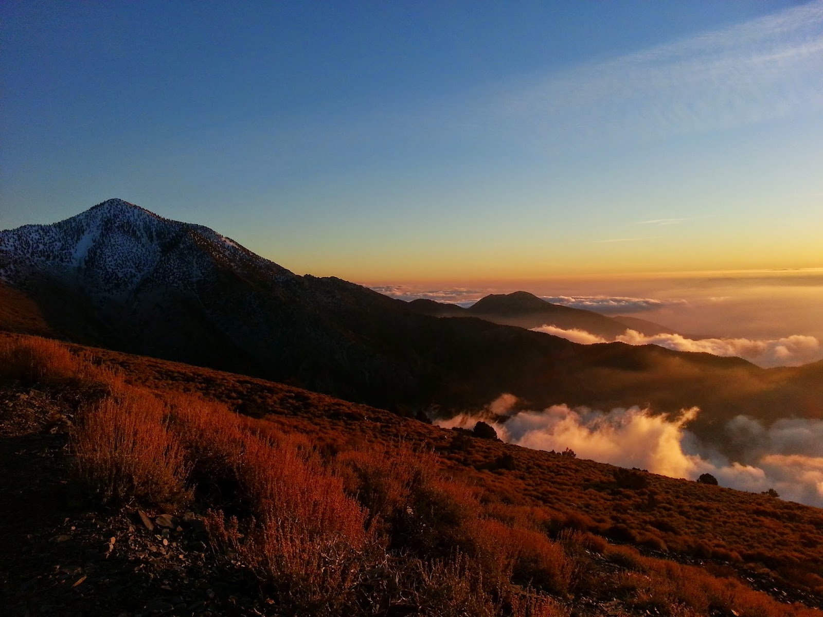
I popped above the fog on a famous ridge named Arcane Meadows and gazed out at a sea of frothing swirling clouds choking the Panamint Valley. They were lit up by the bright desert sun, it was like clouds viewed from an airplane. The tops of the black Argus Range were visable between me and the ice blue crystals of the Sierras. Mt. Whitney looked like you could reach out and touch it. The color palate on that ridge was what you would expect in heaven: the clouds were white but defined by their intense sky blue and indigo relief and the land was gold fading to sparkling white where the snow began. The clouds had been vanishing over Death Valley and even the tawny desert far below was tinted blue, a filter on the land.


In sharp contrast to the blue air was the contorted yellow forms in the foreground. The Limber Pine, its trunk gnarled and sunbleached amber and bronze making patterns that look like twisted candycane stripes. Finally you meet the nobel Bristlecones, these sentinels have been standing guard over Death Valley for upwards of 4000 years, the oldest one, named Methusela, is 5064 years old. The oldest living creature on earth. Her location deep in Death Valley's White Mountains is kept a coveted secret.


So if I am seeing them now, it means Im over 10,000 feet in elevation, and sure enough, I'm crunching on snow. It really wasn't bad though! I had my trusty ice axe which was helping me balance, but there were footprints to follow. There was maybe a foot of snow but I could always make out where the switchbacking trail was leading. It was never too narrow for comfort, the face never to steep where I couldn't perform a self arrest with my ice axe if need be. Maybe that would be different if there was two more feet of snow...But Telescope is not technical, not exposed. Ski poles or a stick would do just as well as the ice axe. It would certainly be easier with no snow at all, but anyone with the will and the physical ability can do it. Seemingly anytime of the year. Consult the ranger's station before you go, and If the road's passable, give it a shot! You can always turn around if conditions get too extreme.


As I climbed onto the unusually calm and silent summit ridge, again gazing to the west, my view became one of sweeping grandeur the likes of which few things beat. I was standing on some glorious heaven on earth paradise above an ocean of bright, changing, moving clouds. The clouds to the east, towards Nevada, were ripped apart and shredded now, revealing the wild colors and psychedelic stripes of the Funeral Mountains far below, and the vast tan floodplain of Badwater Basin. At 282 below sea level, Badwater is the lowest point in north America. This means you are looking from the summit at an 11,000 foot elevation change to the ground floor, something you can't do in the U.S. outside of Alaska. You also can see Mt. Whitney above the clouds, the highest point in the lower 48, so from Telescope you view the lowest and highest points at the same time. That's why its called Telescope, this fantastic view of mysterious eastern California.


I spent a few hours up there, a few too many, lost in the perfect stillness of that blessed day. Consumed by the silence completely, warmed by the powerful sun. But when the wind did blow it blew the warmth away like blowing out a candle. Then the sun set on me, there was no warmth left, but it was glorious, I actually sat for longer and watched it. Had to get back to camp now, the mountains and clouds every shade of dark blue to contrast the deep orange horizon. Fading to black. Then right after dusk the full moon arrived. It was blood red and rippled like a mirage slowly rising from the sea, turning orange as it rose over the desert.